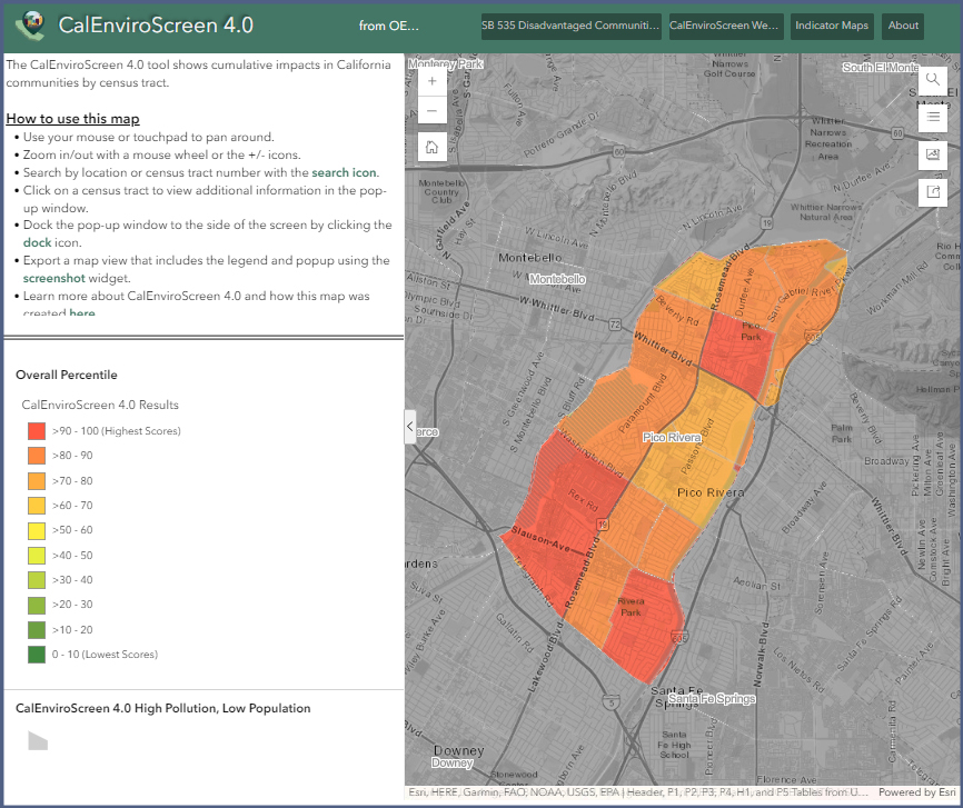
The City of Pico Rivera is surrounded by several state and interstate highways that form the backbone of the regional transportation network, including the Santa Ana Freeway (I-5) to the south, the San Gabriel River Freeway (I-605) to the east, and the Pomona Freeway (CA 60) less than 2 miles to the north. Freeways, being major transportation arteries, have a significant impact on air pollution in the areas they traverse. This impacts the air quality in Pico Rivera immensely which is why the State has designated the City of Pico Rivera, a “Disadvantaged Community”.
Access the CalEnviroScreen 4.0 map below to view more of Pico Rivera’s scores compared to other communities.
Ideally, the Climate Action Plan (CAP) serves as a roadmap to identify sustainability issues and propose implementable and measurable solutions that lead to positive results. The CAP should identify opportunities for economic and social gain through proposed mitigations and adaptations.
The CAP will incorporate several goals and objectives, one of the most notable being compliance with State greenhouse gas (GHG) emissions reduction targets. The CAP also aligns with the State’s efforts to grow the capacity for local jurisdictions and regional agencies to respond to, withstand, and efficiently recover from adverse climate scenarios such as long periods of drought, extreme heat, and power outages.
Residential homeowners and solar panel installation contractors in Pico Rivera are now able to apply for permits online with the help of SolarAPP+, a web-based portal for residential solar energy system installations, developed by the National Renewable Energy Laboratory to automate project plan reviews, receive automated permit, pay fees online, and schedule inspections.
SolarAPP+ Process
Submit solar project for automated review through SolarAPP+.
Click on the Apply button to get to the Residential Solar Permit application.
Please make sure to register and login to complete the online application.
You must have the following information to apply for the Residential Solar Permit.
SolarApp+ approval number.
SolarAPP+ Approval Document with inspection checklist.
Solar contractor and contractor license number.
Pay online and permit will be issued.
Schedule the inspection online.
Login to Pico Rivera Website, find the permit number and perform action to Request Inspection.
Requests for inspection should be made at least twenty-four hours in advance and specific date and time requested is not guaranteed. You will be notified once your inspection is scheduled by the City.
SolarAPP+ Revisions
Log in and submit for a revision through SolarAPP+ and you will be provided with a downloadable revised SolarAPP+ Approval Document.
Upload revised SolarApp+ Approval document.
Login to Pico Rivera website and find the permit number associated with your SolarAPP+ permit.
Perform action to Upload Revision and upload the revised SolarApp+ ApprovalDocument.
In order to expedite your request, please provide the following information:
1. Provide the nearest street address 2. Report any damage to the pole 3. Provide a picture of the pole Some areas may have a large number of poles, please be as specific as possible to ensure we can resolve the issue with the information provided.
Please call us to report vendors
Thank you for your report! If you have any questions or would like to know the status of your request, please contact our Code Enforcement office by calling (562) 801-4332 562 801 4332
Reporting non-emergency crime situations
Thank you for your report! For non-emergency situations, please call or visit the Sheriff’s Station at: LA County Sheriff’s Department : Pico Rivera Station 6631 Passons Boulevard (562) 949-2421.
If you have an emergency, please call 9-1-1. 562 949 2421